BY SEA CANOE
By Reinhard Zollitsch
PEI – the family island
Nancy and I have come up to the island since our early married years, then with our four kids, and we are still enjoying the tranquil rural landscape and the stunning red and white coast-line now that the kids have left home and are almost all out of college.
In recent summers I have been especially interested in the PEI coast- line. Having done a lot of sea-canoeing along our shores from Boston to Machias, Maine, it was only a matter of time when I would venture out into the waters cradling this beautiful island in the Gulf of St. Lawrence.
I did not set out to circumnavigate the entire island, all 400 miles, in one long uninterrupted trip, but rather do it in stages, like three days or 75 miles each summer, so I would not miss out on the family fun and be missed too long by the family.
Since we had always come to the island in mid-June, when school vacation starts in Maine, my canoe trips mostly started out on or around Father’s Day. And I thought to myself, what a great present for a dad, to be given the confidence, trust and family support to carry out a venture like this.
A circumnavigation in stages
The first stage was an easy decision: from North Cape 60 miles back to our home base at Cavendish. As usual, I was fully self-contained with tent, sleeping bag, food, water and small propane cook-stove. “After three days keep a look-out for a lone canoeist approaching the beach,” I told the kids, and they did - and I was right on time having had a wonderful time along the long sand-spit islands off Cascumpec, Malpeque and New London Bay and awesome, majestic, steep red cliffs in between, especially the Cape Tryon area.
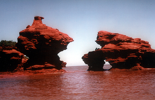
Red sandstone shore
My second over-night stop, on Hog Island, though, was a different story. I was all set up on a slight elevation along the ocean shore when a violent thunderstorm passed right overhead. Being the highest point for miles and all alone, I did not feel like taking chances of being fried in my tent, so I curled up in a tarp near shore.
When the storm finally passed, the mosquitoes came out, all night and all morning, thick voracious clouds of them. I donned my head net, soaked up a bottle of Bens, but to no avail: the beasts bit through my clothing without mercy. Somehow I also misplaced my favorite Oakleys in the confusion there, and two days later my entire body broke out in those all too familiar poison ivy blisters. Enough said.
Year two
Next year was windier and I made it only to Tracadie. The shoreline was stunning, though, along the PEI National Park past Orby and Turner Head and along the white beaches and dunes at Covehead, Stanhope and Dalvay. But I had my eyes on the ocean and learned the limits of my old 16’ open solo white-water racing canoe by Jensen. So I decided to invest in a new boat, a semi-decked 17’2” sea-canoe by Verlen Kruger. It has a rudder and spray skirt like a sea-kayak, but I still sit elevated like in a canoe and propel the boat with a single bladed canoe paddle, a high-tech 11 oz. bent-shaft user-friendly carbon-fiber wonder.

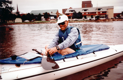
My new sea canoe
Year three
My circumnavigation started in earnest the next year when I was able to reel off two 31 milers (50 km) from Tracadie to Naufrage and then on around East Point to Basin Head. Naufrage was a most interesting harbor with a very narrow channel entrance through which the tides were running hard. Behind it was a tidal lake-like harbor where the lobster boats were moored five deep. Before sunrise the harbor came to life when one boat after the other shot through the channel into the ocean like a bat out of a cave. A never-ending stream of boats, it seemed. I decided to stay out of their way on the beach near the entrance.

Moored five deep in Naufrage Harbor
Rounding East Point could have been much worse. There was lots of surf off the point where the two currents meet, but the inside sneak through a narrow segment where the waves seemed to cancel each other out, worked out fine, i.e. was doable. But then the tide was setting hard against me and I had to eddy-hop or slug it out all the way up the coast to Basin Head. Souris was our predetermined take-out spot the next morning, and Nancy was there to celebrate the point rounding.

Brief break before rounding East Point
Year four
When next year’s stage was discussed, the confidence and trust level of my family had risen even more and I clearly heard Nancy say: “Charlottetown would sound good.” Over100 miles? I would need at least 3 1/2 days. I accepted my Father’s Day present and challenge and went for it, also because the pick-up was going to be nice and easy.
Charlottetown would sound good
From Souris I went around one point after another - Howe, Durell and the very toothy Spry Point - all the way and across to Panmure Island, a very long 9 hrs in the boat, or 31 mi/50 km. Next day was equally tense canoeing off a very steep and very inhospitable looking shore stretching from Murray Head past High Bank to just before the Wood Island ferry. In retrospect, the shore looked awesome, proud and beautiful and was a stark contrast to the reading of my trip, Paul Theroux’s book about the British Isles: KINGDOM BY THE SEA.
Rounding Point Prim the next day was a very memorable and trying moment. Its long sharp ledges extend far into Northumberland Strait, and the ebb flow out of Orwell Bay was horrific, confused further by a strong westerly. The breaking tidal rip reached all the way into the bay, and I was dancing, trying to out-sprint the breaking parts of the waves with some serious “oh no!” type of braces thrown in. It was tense, it was exciting, more so in retrospect than in actuality - I was on the edge and had to get out of there, which I finally did, after 2 hours.
Year five
From Charlottetown back up to North Cape seemed like two perfect 3-day, 75-mile summers, and that’s exactly as it happened in 1999 and this June of the year 2000. I was able to hop across the long bar to St. Peter’s Island and on around several points to Victoria, where I pitched my little green Timberline tent on a small patch of grassy/duny sand near the lighthouse.
I had seen the new (1997) 9-mile-long PEI bridge for quite some time, but it seemed to take an eternity to get to Borden and the bridge itself. The tide was rushing at me under the bridge. I had to come up in the eddy behind one of those huge “feet”. One quick touch with the paddle and then ferry across the fast water to the right and up into the first bight. From my point of view in my little 17’ sea-canoe, Prince Edward Island is still an island, even though I notice the rapid change of the island communities as a summer guest.

PEI Bridge
The stretch up to Seacow Head lighthouse had some spectacular views of the entire bridge, a true engineering marvel. The night was spent at the base of the breakwater on MacCallum’s Point leading out to Indian Head Light at the entrance to Summerside harbor, a perfect overnight spot.
Cape Egmont the next day required some strong and skilled paddling because the tide was running hard against me again. But I had to get around the steep point and past Red Head and into the bight at Maximeville, our predetermined take-out point for that year. Well, I made it to the long sand-spit extending into the bight when I felt sure the rest should be a piece of cake. But suddenly there was a line of impenetrable breakers as far as the eye could see, not just along this sand spit, but all the way up big Egmont Bay, for 4 or 5 miles.
How am I supposed to get through that stuff into the bight to Maximeville and the route 11 bridge, I thought, when I suddenly noticed two small buoys in the water, one red, one green, and two directional lights on shore. This is it, this is your chance. I took aim for the smoothest stretch, picked up speed and braced and surfed down the big waves into the calmer waters leading to the harbor entrance.
Year six
I had thought about this place many times over the winter. Would it be as rough again the next year, the year I hoped to finish my circumnavigation? Naah, you can’t hit the same tide and the same tidal rip two years in a row --- But when we drove down route 124 and 11 this June, on Father’s Day again, we not only saw 4 miles of breaking waves, but heard the surf from high up on the road. My heart sank and I am sure that of my dear wife too; but we did not say anything. So here we go again, I thought; it is never easy, or as my teacher way back then used to tell me: “Reinhard, life is one of the hardest.”
The put-in in the harbor was calm, very quiet and a bit surreal. I had decided not to go out through the opening and slug it out with the elements, but try to sneak along the shore between outer tidal rip break and inner shore break. And it worked all the way to Rocky Point, for an entire hour, but then suddenly I ran out of water or the rip decided to touch shore, and I felt I had to jump through the surf and dance the waves as best I could, for a bit at least, before I could scoot in again.
I made it fine through the surf, adrenalin was kicking in and I was doing great for a while, out-sprinting the breaking waves and dancing along, with the bow slightly pointed into the waves. But then the waves came faster and were more confused. I got smacked in the face by the waves several times, water forced its way into the boat despite the spray skirt and I was wet down to my underwear again - - I had to get out of there fast. And while I was thinking that, a wave caught me and I had to brace, and it pushed me sideways, and I had to brace some more till my low brace was sinking lower and lower in the water and I had the distinct notion of rolling over.
OH NO, I yelled and with one last mighty heave I tried to right my boat again. It worked, I paddled frantically, now aiming for the beach between breakers, surfing, accelerating, leaning back and bracing on the rushing wave crest - and finally made it back towards shore—but I had pulled some muscles on my right rib cage from that mighty wrench. I was hurting, and it was only two hours into the trip. What a bummer.
At the tiny harbor of Sandy Point I found my Tylenol and found out I could still paddle, mostly on the left, but with greatly reduced power. So no excuse to stop, and on I went. Crossing Percival Bay with a 20-25 knot northerly was another trying ride, when at times I feared being washed back down the entire bay to where I had come from - not a pretty picture. But after the finger-like Grande Dique Point I got into more sheltered but also shallower waters. West Point Harbor looked very good that afternoon after having struggled in my boat for 8 hrs with only a 20-minute lunch break. I was exhausted and hurting, but left a message for Nancy at our campground in Cavendish that all was well at West Point. I had made it; that was all that mattered...
The weather report for the next two days was great: sunny, and light winds out of the west. By sunrise I was on the water - the fishermen had already gone out at 4:00 AM. The 43 miles along the western shore of the island, between West Point and North Cape, are truly spectacular and with its steep ragged sandstone shores very formidable for small boaters. Howards Cove was the only little harbor along today’s 25-mile stretch to Miminegash. But I did not stop there - I kept on paddling - and made it non-stop up into the harbor of Miminegash through the narrow breakwaters with the tide ebbing hard. Suddenly I felt very accomplished . I had made it to Miminegash - I always liked that name - and I was getting real close to North Cape now, the end of my circumnavigation.
I had already pitched my tent near the bridge spanning the large tidal inlet behind the harbor proper, when I refigured the tides for tomorrow morning. This morning the tide was nice and high before 6:00 am and I should be able to flush out of here without a problem, I thought. But to make sure, I asked a couple of local fishermen what the tide would be doing tomorrow morning around sunrise. “It will flood so hard you won’t be able to get out on your own power. There is an almost full moon.” They were unanimous, and I believed them. So I broke camp, packed up again, and set up camp outside the harbor on the beach.
And they were right. Before I was about to push off for North Cape the next morning, I checked the current in the channel, and it was flooding so hard it was cresting. 18 more miles to go! The fishermen went out before sunrise, mostly to collect Irish moss, since the lobster season on the west coast of PEI starts in August, not June. This way there are lobsters most of the summer on the island.
The steep shore was only briefly interrupted by long undulating duny sand-spits near Nail Pond. Then it got steep again, and I was waiting for the tide to rip or cause problems.
I surely would not want to be here in anything but the best of weather conditions, and I lucked out, it was splendid: sunny with unrestricted visibility, a light westerly wind, no rips, no breakers other than the usual shore breakers or breaking waves over rock outcroppings. I was wishing the Cape with its lighthouse into view, but it would not do me the favor. Many times I felt I must be at the point, but then there were always one or even more points beyond the last one, till all of a sudden, there it was, with a huge antenna near it.
End of trip
This is it, I thought, nothing can stop you now. Hang in there, two more points, then hop across the one-mile-long bar and you are home. There was even enough water on it so I did not have to go out too far. And then rounding the last point I saw my familiar van, and there was Nancy, camera in hand to record the event.
I had made it and was feeling very accomplished and for a moment forgot my hurting chest. 400 miles in 16 days total for an average of 25 miles per day over a span of 6 years. What an adventure and what great scenery there is to see from the ocean. How different from driving point to point. And if you ask me, PEI is still an island, despite the new bridge. I got my certificate at the North Cape pavilion with the additional note of CANOED AROUND THE ISLAND printed on it. After the flawless conclusion, all seemed suddenly easy—the hardest part now was getting my 55-pound boat back on top of the van. Ouch.

"Ouch!" (loading boat on van)
Info:
Before heading out to PEI, check out their official web site at:
http://www.gov.pe.ca/visitorsguide
Click on THINGS TO DO, KAYAKING, KAYAK RENTALS, if you don’t have your own boat with you.
Check out PICTURES for a first glance at the island and plan where you want to stay well in advance - some areas of the island are very popular with the normal tourists.
If you decide to do some serious paddling, make sure you get official nautical charts ahead of time or stop in at ‘Coastal Stevedoring’ on Water St. in Summerside, as I do. (The official PEI road map just won’t do - don’t try it!)
Here are some pertinent chart numbers to consider for PEI: 4403, 4405, 4905, 4906, 4491, 4467, 4425.
Work out your courses ahead of time and write them on your chart in pencil. Have a compass mounted in front of you in case you get fogged in suddenly. (You cannot paddle in the fog with a hand-held compass!)
Remember, there are lots of points to go around, and tides can make it real rough for you or strand you way offshore. So don’t forget to plan in the tides and carry an official tide table with you. (Tides on the Northshore are different from the tides in the Northumberland Strait!)
If the weather does not allow you to go offshore, don’t be dismayed; explore one of the many large protected bays or rivers. You can always find some place to paddle on PEI. So don’t get obsessed, and make the best of your limited time and weather window. Always have an alternate plan ready, and carry a weather radio.
Leave your itinerary with another person. Call in periodically from a public harbor phone or bring a cell phone. I always carry a VHF marine radio-telephone with weather channels with me, and yes, I always wear my life jacket with whistle.
Now, have fun, be prudent (don’t paddle beyond your ability) and you will enjoy this beautiful red and white “island cradled by the sea”.
© Reinhard Zollitsch
BACK TO TOP OF PAGE