by Reinhard Zollitsch
August, 2010
I know I said I would stay away from tide-ridden saltwater shores, and especially tide rips, come 2010; and I did, deciding instead to circumnavigate our biggest lake in New England, and 6th largest lake in the US, Lake Champlain. With the 400-year hype of 2009 over (Samuel de Champlain canoed and named this lake in 1609), I felt it was a sensible compromise for the "old salt".
Don't get me wrong, it was a wonderful 276-mile round trip (see my write-up in the October issues of MESSING ABOUT IN BOATS and ATLANTIC COASTAL KAYAKER and on my website (www.ZollitschCanoeAdventures.com), but there was something distinctly missing: the air, the smells, the open vistas and curved horizon, the challenge of irregular waves, swells from distant storms, and the ever-changing water level: no tides, no rips, no salt spray or spindrift, no wild dancing, no bells, gongs or whistles, and not enough gulls, terns and other seabirds. --- I missed it all already, on my first trip away from all that stuff.
Lines from John Masefield's poem Sea-Fever kept going through my mind, till I finally succumbed and decided to do something about it. Yes, "I must down to the seas again, to the lonely sea and the sky, And all I ask is a tall ship and a star to steer her by," or in my case, my trusty old Verlen Kruger SEA WIND solo sea canoe, my carbon bent-shaft paddle, my Ritchie compass and my beloved NOAA charts. I felt the distinct need to do some serious messing about on salt water, and why not revisit some of my favorite haunts on Muscongus Bay in Maine. "Messing about on Muscongus, Maine" sounded good. It even had some very literary alliteration to make up for my humble Eureka abode, canned dinner menu by Bush, Hormel, Dinty Moore and Chef Boyardee, and my coffee and cereal with fat-free powdered milk.

Click map to enlarge in a new window
Since Nancy kindly offered to drive me to the put-in, I chose Thomaston harbor, the closest Muscongus port to Orono, Maine, only 2 hours from home. This way I did not have to worry about leaving my car unattended for 6 days at some public ramp, where overnight parking is also mostly forbidden or ill-advised. Looking at the chart, my 6-day trip fell into place very quickly. The first day I would paddle the 10 miles down the St. George River into the bay and pick a MITA (Maine Island Trail Association, see appendix) island to camp on for the night. Having been a MITA member for 17 years, I thought I would check out every Muscongus MITA spot in the process and report back to Headquarters.
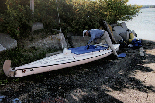 Put-in in Thomaston
Along the eastern edge of Muscongus Bay
For the first night out I had picked tiny Griffin Island at Davis Strait, just a tad north of Benner and Allen Island. My first day's paddle would delineate the eastern edge of Muscongus Bay. I was very familiar with this area, especially Davis Strait, because of earlier family sailing trips in our little 22' Venture swing-keeler on the way from Port Clyde to Pemaquid Point.

I am off - what a feeling!
The St. George River (also known as The Georges, or St. Georges River) is really a very wide and even longer tidal arm, which must have looked like the Northwest Passage to all the early explorers, obsessed to find that fabled passage to the riches of the Orient. Champlain came looking for it up the Penobscot River in Maine (1604) as well as the St. Lawrence River in Canada, all the way up to the Lachine Rapids in Montreal, the China Rapids (1602), as did Jacques Cartier before him (1535). Captain George Waymouth (in most modern popular literature spelled with an "e" - Weymouth) checked out the St. George River in May/June 1605, but was mostly looking for possibilities for a British settlement in the New World.
I passed very picturesque inlets like Maple Juice Cove, made famous by paintings by Andrew Wyeth, saw a most delightful tidal short-cut behind Gay Island and a handful of very ledgy looking islands between Caldwell, McGee and Thompson Island. Griffin Island and Ledge were a treeless delight. There even was a small flow-through shell beach, which made landing real easy, especially from the south at about mid tide. I saw several eagles on the way out here, lots of eiders and loons, as I watched sailors and lobster boats and also a few pleasure craft pass through this narrow passage.

Davis Strait from Griffin Island
The traverse
All afternoon and especially the next morning I was longingly looking over to Monhegan Island, only 10 miles south of my rock-pile perch on Griffin Ledge, but tackling an eight-mile open ocean passage (from the southern tip of Allen Island) and the same distance back did not seem prudent in late August, and all alone, and I opted for a big traverse of Muscongus Bay instead. At the anchorage between Benner and Allen Island, also known as Georges or Pentecost Harbor, I tried to recall what I had read about the early explorer Waymouth, who anchored his boat the Archangell here during May and June of 1605, even celebrating mass on Pentecost Sunday on the very spot where you now find a large granite cross. (On it the name Waymouth, with an "a" , was clearly visible from my boat perch.)

Waymouth cross on Allen Island
A very proper cruising yacht, a sizable yawl, was anchored on the same spot Waymouth must have chosen 400+ years ago. The crew was having breakfast in the cockpit. "What a great day in a very special place," I quietly voiced in their direction. I did not get (or need) much more than a nod and a smile, and I was out of sight towards Old Hump Ledge, Franklin Light and Harbor Island, which I had wanted to sail into for a very long time, but never did. This time I would paddle into the natural harbor over the ledgy south entrance and out the top. The three boats anchored there looked just as safe and cozy as I had always imagined. From there I would continue my traverse past Wreck, Ross and Haddock towards New Harbor and Pemaquid Point. But since I was in such a mellow, non-people mood, I decided to skip those two tourist places and instead check out two tiny MITA islands in that area, Bar Island at the southern tip of Louds Island, and Little Marsh, south of Marsh Island. And since Bar was taken by two young paddlers, I opted for Little Marsh, a bold, almost white ledge with two and a half spruce trees on top, offering just enough shade for my little tent.
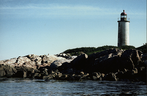
Franklin Island lighthouse
Landing and launching the next day, though, over ledges covered with seaweed, was a bit more challenging than on the lovely Griffin Island shell beach. But the view straight out to sea over low, treeless Eastern Egg Rock with its small Puffin colony, across to Pemaquid in the SW and Monhegan on the SE horizon, was spectacular.
Up the western edge of Muscongus Bay
Early the next morning I crossed Muscongus Sound to follow its western shore to Round Pond, where I had sailed into many times with my family, almost always in the fog. Today was different – sunny and clear, which made everybody very friendly. The tide was also with me, and sitting in a hand-powered boat in quite sheltered water I did not have to worry about the wind, as I did in the past while sailing, tacking against the tide through the very tight, ledge-studded Hockomock Channel. I even went behind Oar Island to finally see the wooden five-masted schooner Cora Cressey, beached there on the mud flats. She was built in Bath, Maine (1902) for the coal trade, being able to haul 2193 tons, but she ended up in Boston as a floating nightclub (1938), and when that failed, she was towed to its present location and served as a lobster pound, till her sides rotted out. I could not bring myself to take a picture of the old schooner hulk. It looked so abandoned, so sad, so dilapidated, so disrespectfully disposed of, slowly rotting into the mud. They should have poured gasoline on it years ago and had a glorious bonfire instead, as the Vikings did with their boats, or they should have scuttled it far out at sea; in either case, giving it a proper burial, sending its spirits free.
After that I pushed on with the remaining tide all the way up to Waldoboro, 16 miles up the Sound. Many an old coastal schooner, including the sister ship to Cora Cressey, the Paul Palmer, was built here in Waldoboro (in the same year of 1902), which I understand was mostly settled by Germans. I looked all around for the old shipyards – nothing, no boat shed, ramp, ways, forgotten logs or planks, absolutely nothing but two stone piers, one modern floating dock with one lobster boat tied to it, and one rowboat in the marsh grass in front of an old factory building which still seemed to be producing something, because the lights were still on.
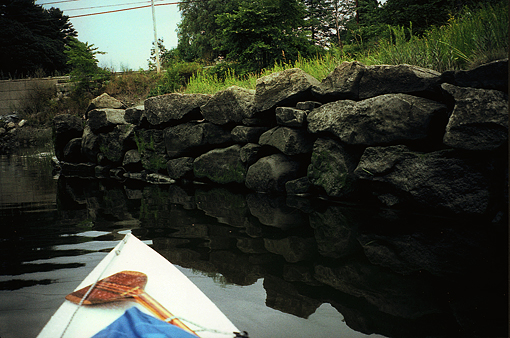
Old stone pier in Waldoboro
The tide then ran out fast, leaving extensive grass-covered tidal mudflats on both shores. My chart indicated only a very thin channel at low water. Five miles below Waldoboro, I pulled out at the narrows of Havener Ledge. A small beach at the south side made landing easy, but lugging my camping gear up on top of that huge granite outcropping took some huffing and puffing. The view from the top of the ledge, though, was worth it, and the tiny one-tent camping spot right on its shoulder was very protected. A family with 4 kids had a friendly picnic on the beach. Answering all the questions the young kids had and showing them how all my gear worked, from my paddle, to compass, radar reflector, wiggle stick, tent, Crazy Creek chair and stove, was fun, being an "old teach". I like curious people and always reward them.
Havener Ledge
More MITA sites in the middle of Muscongus
The next day was designed to criss-cross the center of Muscongus Bay, ending up on Thief Island. I checked out the sites on Hungry, Strawberry and Crow Island, where I met an older solo canoeist in a short, shallow, flat-bottomed OLD TOWN camp-style canoe, which he propelled with a set of well-worn wooden kayak paddles. He seemed to be having a great time and claimed to have paddled all over the place. I was impressed, but was glad I was sitting in my covered Kuger sea canoe instead of that nutshell. Then I enjoyed a most charming passage behind Wolsgrover and Wharton Island, but when I stuck my bow back out into the Medomak River, it got windy. Whitecaps were forming in a hurry, and I danced my way from Hog to Louds I., using Indian I. as the last jump-off point to Thief I. The tide was such that I had to land on hard rock – ouch! and had to weight my tent down from the inside before I could raise it. But soon all was fine again in that little, protected, sumac grove campsite. Coffee and hot cocoa and eventually my culinary friend Dinty Moore lifted my spirits. I think it was beef stew, or maybe chicken stew; but then, they all taste alike in saltwater surroundings, especially when you "wash" your dishes in that brine – but mind you, I am not complaining here, just stating the way it is.

View from Thief I.
Friendship and the islands to the south
The strong southeasterly of yesterday had changed to a strong northeasterly, as I crossed over from Thief to Black I. and from there right into the wind up into Friendship Harbor. I had to go there, for sure, if only to find a few old-fashioned Friendship sloops. My first sailing experience along the Maine coast was with a family friend sailing his home-built Friendship sloop, the Nancy (same as my wife Nancy). We sailed her from Portland to Boothbay, Friendship and Camden many times; so I was on the look-out for her or any other beautiful classic gaff-rigged fishing sloop. And finally I saw one: the mighty Gladiator, one of the finest and fastest Friendship sloops around these days.
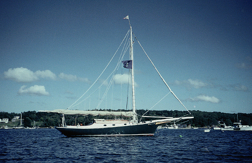
Friendship sloop in Friendship Harbor
Later that afternoon I saw her sail to Harbor Island and back under full sail. By then the wind had picked up even more, and the skipper had to luff jib and main to stay upright. I guessed he was sailing shorthanded and didn't have enough crew to reef both sails. Had I been aboard as a boatswain and had at least one other sailor to help me, I would have suggested tying in two reefs. (As a matter of fact, he should have reefed while still on his mooring, if he had listened to the NOAA weather report!)
After swinging around Garrison and Morse Island, I flew SW before the wind and was chased by breaking waves back to Black Island, where I had to land on the rocks again, between two huge erratics on the NE side, where you see those lovely lilac bushes up on shore. The camp site was flat, grassy and very sheltered, but at low tide, like tomorrow morning, when I had planned to leave, the rocks looked impenetrable with a heavy boat and gear, like real ankle twisters, which you cannot afford going solo. So I decided to break camp and carry my boat and all my gear along shore to the NE tip of the island, where there was a level seawall to camp on and a gently sloping beach to get to the water on. Better do it now than early in the morning, when it may also rain. I noted in the MITA site booklet for the lilac site, not to camp here if you plan on leaving around low tide.

Landing on Black Island
The weather report for the next few days did not sound very promising: strong north-easterlies with heavy rain starting about 10:00 a.m. It was time to get off the bay. I was suddenly done. I had sniffed enough salt air, even tasted some salt water on my lips, danced enough to feel good and excited, but never out of control. It was a perfect 6-day loop through the island world of Muscongus. All I had to do now was power my way 14.5 miles up the St. George River with the tide, but against the wind, back up to Thomaston, where I was to meet Nancy at High Noon, as usual.
And yes, at 12:00 noon I rounded the last corner, and there was my car and Nancy in her Gore-Tex suit and inside-out umbrella to protect her camera. What a girl! Thanks! It rained in buckets, but all my gear was in dry bags, so who cares. Nancy had even brought dry clothes for me. I briefly looked up at the other Waymouth cross on shore, nodded respectfully, and then we were off.

Rainy arrival back in Thomaston
Summary
84 mostly leisurely miles in six days (14 miles/day on average in 4.1 hrs/day), a much gentler pace than my usual 25 miles/day, when I am on a real trip to somewhere. On all MITA sites I was always alone. I saw only three other boaters in six days. Even in late August, the ocean is still not over- crowded, because it does take an effort to get out, always, and some skill, strength, but especially prudence to know when to persevere or when to quietly quit and pull out.
Yes, I needed that salt air, and I feel much better going into Fall and our long winter-hibernation period up here in Maine. I already know I'll certainly be "down to the seas again" next year.
You too, keep paddling, be safe and enjoy.
Reinhard
www.ZollitschCanoeAdventures.com
PS: I hadn't actually read Sea-Fever since my college days almost 50 years ago, and had not memorized it. But I just re-read it, after finishing this article, and I am amazed at how very accurately the poem describes my own feelings! I am attaching a copy of the poem to share with you readers.
SEA-FEVER
I must down to the seas again, to the lonely sea and the sky,
And all I ask is a tall ship and a star to steer her by,
And the wheel's kick and the wind's song and the white sail's shaking,
And the grey mist on the sea's face, and a grey dawn breaking.
I must down to the seas again, for the call of the running tide
Is a wild call and a clear call that may not be denied;
And all I ask is a windy day with the white clouds flying,
And the flung spray and the blown spume, and the sea-gulls crying.
I must down to the seas again, to the vagrant gypsy life,
To the gull's way and the whale's way where the wind's like a whetted knife;
And all I ask is a merry yarn from a laughing fellow-rover
And quiet sleep and a sweet dream when the long trick's over.
By John Masefield (1878-1967)
(English Poet Laureate, 1930-1967.)
GEAR AND INFO
17'2" Verlen Kruger SEA WIND sea canoe (www.krugercanoes.com)
carbon fiber Zaveral marathon canoe racing paddle (www.zre.com)
NOAA chart #13301 (Muscongus Bay)
Iridium Satellite Phone; VHF marine radio with 24-hr weather reports
Camping gear for beach overnights; one-burner propane stove; all food from home; 4 gals./16 liters of water in Dromedary water bags; adhering strictly to MITA carry-in/carry-out policy
Maine Island Trail Association, Portland, Maine: www.MITA.org
On Waymouth, check out: www.thomastonhistoricalsociety.com/weymouth.html
On Cora Cressey, check out: www.CoraCressey.pdf
Expenses: None, other than food and car shuttle
Sponsors: None (no obligation, no stress)
© Reinhard Zollitsch
BACK TO TOP OF PAGE